By Dr. Alan Barton, Director
NMFWRI
In the 21st century, collaboration has played an increasingly important role in coordinating resource management across large landscapes. One of the great collaborative groups in New Mexico is the Coordinating Group convened by the New Mexico Forestry Division’s Office of Forest and Watershed Health. This group—which brings together professionals who work in forestry from various perspectives—has been meeting quarterly since 2006, and is a great venue for foresters to keep connected and informed about all aspects of forestry in the state. Over the years, many valuable ideas have emerged from the discussions held at these meetings.
In 2014, the chair of the FWH Coordinating Group proposed creating a database and map of vegetation treatments around the state. NMFWRI took on this task and produced our New Mexico Vegetation Treatment Geodatabase, a popular decision-support tool that maps and provides information on treatments in New Mexico over the past three decades.
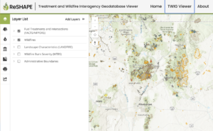
Congress saw the utility of the New Mexico Vegetation Treatment Geodatabase, and in the Infrastructure Investment and Jobs Act of 2021, Congress provided funding to the Southwest Ecological Restoration Institutes (SWERI), the NMFWRI’s consortium, to produce a national version of the New Mexico map. Taking up this challenge, the NMFWRI’s GIS Team assembled a partnership with staff from the other SWERIs, an advisory group from federal agencies, and Innovate!, a Virginia-based firm of GIS consultants. Together they put together a program of work and collaborating with GIS specialists from the U.S. Forest Service and Department of Interior agencies, they have produced a database and map of vegetation treatments and wildfires on federal lands in all 50 states and U.S. territories. The map, dubbed the Treatment and Wildfire Interagency Geodatabase (TWIG), is now available to the public and includes filters to select for specific characteristics. Click on [Tour] or the (?) link at the lower left corner of the site for an introduction to using the map.
All of us at the NMFWRI hope that our partners and land managers throughout the country find this tool to be useful, practical, and informative.