Opportunity Map Webinar
The following video is a recording of a webinar held on March 31, 2021. Watch the video to learn how to use the data available
The following video is a recording of a webinar held on March 31, 2021. Watch the video to learn how to use the data available
Title of Project:Social Impact Assessment of the Collaborative Forest Restoration Program Location: This research project takes place in the State of New Mexico. Principal Investigator:
Title of Project: Social Impact Assessment of the Collaborative Forest Restoration Program Location: This research project takes place in the State of New Mexico. Principal
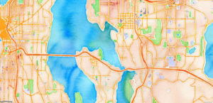
January – March 2021 Maps are a proven way to bring partners around the table and identify areas and issues of common concern. Everything happens
What is LiDAR? LiDAR stands for Light Detection and Ranging. LiDAR data provides high levels of detail and precision in describing elevation. Products derived from
Two new staff members have joined our team at NMFWRI this year. In July, Elliese Wright was hired as a Collaboration Specialist through the Americorps
Web-based GIS modules for virtually exploring and interpreting the Mora watershed using ESRI GIS technology. What is a watershed? I am sure you have heard