Research institutes in Arizona, Colorado, and New Mexico are reshaping wildfire and fuel reduction information with a new nationwide, open-access geodatabase that will change the way critical data on fuel treatments and wildfires are accessed and understood, leading to more effective wildfire prevention strategies.
Policymakers, land management agencies and the research community have long faced challenges in accessing past, current and future fuel treatment data, along with the need to understand treatment effects before, during and after wildfires.
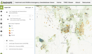
The launch of the Treatment and Wildfire Interagency Geodatabase, known as TWIG, now provides an open-access platform where all federal fuel treatment and wildfire data can be viewed, downloaded and analyzed. This comprehensive data compilation enables users to assess, plan and monitor fuel treatment interactions with wildfires across boundaries.
“As wildfires continue to pose a significant threat, tools like TWIG are essential for proactive planning and management,” said Andrew Sánchez Meador, executive director of the Ecological Restoration Institute at Northern Arizona University. “TWIG not only provides access to critical data but also promotes collaboration and transparency among researchers, land managers, and policymakers.”

TWIG was developed through the ReSHAPE program, which is led by the Southwest Ecological Restoration Institutes, or SWERI. For this national project, SWERI received funds from the Infrastructure Investment and Jobs Act passed by Congress in 2021. SWERI has been working on this program in partnership with the US Department of Agriculture Forest Service and the Department of Interior Office of Wildland Fire, facilitating access to and application of cross- boundary fuel treatment data.
With the beta version of TWIG now available, SWERI is actively facilitating use of the tool, addressing data nuances and gathering feedback. User feedback will inform ongoing development and enhancements to ensure the tool meets users’ needs. This approach enables SWERI to effectively integrate with existing initiatives and avoid duplicating efforts.
“With TWIG, we are building a platform to meet the audience’s needs,” said Aaron Kimple, ReSHAPE program director. “We are encouraging users to explore TWIG and provide feedback, which is essential to refining this new tool.”
Explore the TWIG viewer live today.
About the Southwest Ecological Restoration Institutes
The Southwest Ecological Restoration Institutes (SWERI) were authorized by Congress in 2004 to ensure that best available science informs the development, implementation, and monitoring of forest restoration treatments. The institutes include the New Mexico Forest and Watershed Restoration Institute (NMFWRI) at New Mexico Highlands University, the Colorado Forest Restoration Institute (CFRI) at Colorado State University, and the at Northern Arizona University. These institutes co-develop, translate, and apply actionable knowledge in collaboration with forest land managers and partners to foster fire-resilient forests for the benefit of communities and nature, now and in the future. SWERI were identified in the 2021 Bipartisan Infrastructure Law (BIL), to undertake a national wildfire and treatment effectiveness mapping and assessment project. The resulting effort is the ReSHAPE Program. To learn more, visit the SWERI and the ReSHAPE program websites.
