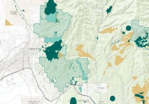
Nationwide vegetation treatment map, geodatabase launches
Research institutes in Arizona, Colorado, and New Mexico are reshaping wildfire and fuel reduction information with a new nationwide, open-access geodatabase that will change the

Research institutes in Arizona, Colorado, and New Mexico are reshaping wildfire and fuel reduction information with a new nationwide, open-access geodatabase that will change the

Southwest Ecological Restoration Institutes (SWERI) are hosting a cross-boundary workshop in May to explore the ways land managers and communities can prepare for the new

NMFWRI is seeking a Geographic Information Systems (GIS) Coordinatorwith a focus on developing forestry and wildfire mapping applications.This position will support NMFWRI and our partners

The Southwest Ecological Restoration Institutes are coordinating a cross-boundary workshop to discuss ways of adapting to a rapidly changing Western landscape. Save your spot soon!

Join the Rocky Mountain Research Station and the Southwest Ecological Restoration Institutes Nov. 9 for a series of lightning talks exploring tree seedlings, Indigenous knowledge,