The New Mexico Forest and Watershed Restoration Institute’s Ecological Monitoring Program maintains a professionally managed field crew to collect and analyze data on short and long-term ecosystem responses to restoration treatments and wildfire, providing a critical scientific basis for adaptive management decisions and improved forest treatment effectiveness. We have collaborated with more than 40 partners to monitor sites throughout New Mexico, Colorado and Arizona since 2007 and have collected over 2,500 plots across over 64,000 acres.
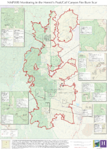
Our data on the sites displayed in this map includes many of the following collections:
pre-treatment, immediate post-treatment, 5- , 10- and 15-yr post-treatment, and post-wildfire. At these sites we collect fuels (Brown’s) transects and planar intercept cylinders (to quantify fuel loads including ladder fuels); ground and aerial cover by components; counts of woody species and their regeneration under 4.5 ft by species and condition; and overstory tree species, condition, damage/disease/severity, diameter, height, and live crown base height. We also have photo series on many of these sites across monitoring periods. All data is put through a multi-step Quality Control process. Information on how we met our Measurement Quality Objectives is available for data after 2023.
All data on these projects, along with all others in our network (excluding confidential Tribal data) are available upon request. We can deliver data in various formats, along with technical support for analysis and interpretation. Please reach out!