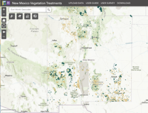
A team from the New Mexico Forest and Watershed Restoration Institute has built an extensive geospatial database of vegetation treatments around the state that can help fire researchers and land managers. The database encompasses treatments such as mechanized tree thinning, prescribed burns, and herbicide use across 9.9 million acres of public land in New Mexico and parts of Colorado, Texas, and Oklahoma over the last 100 years. The NMFWRI team recently published a paper describing the New Mexico Vegetation Treatment Database and the methodology used for collecting data. The data set covers most of the treated state and federal lands in New Mexico dating back to 1910.
The New Mexico Vegetation Treatment Database is regularly updated. Land managers conducting forest treatments can also enter their project information in the database.
The database was one of the models for a project called ReSHAPE, an effort to compile information nationwide on fuel treatments and wildfires. The project is currently in development by the Southwest Ecological Restoration Institutes, including NMFWRI.
 The paper, “A database of vegetation treatments in New Mexico USA and surrounding regions”, is authored by Katahdin Withnall and Patricia Dappen of NMFWRI’s GIS program, NMFWRI Research Associate Nathan Tomczyk, and Joseph Zebrowski, a GIS specialist.
NMFWRI was approved by Congress in 2004 and is federally funded. Institute staff work to reduce catastrophic wildfires and restore resilient, fire- and climate-adapted ecosystems. NMFWRI collaborates with partners and engages communities to bridge scientific and local knowledge and build capacity in landscape-scale adaptive management.